
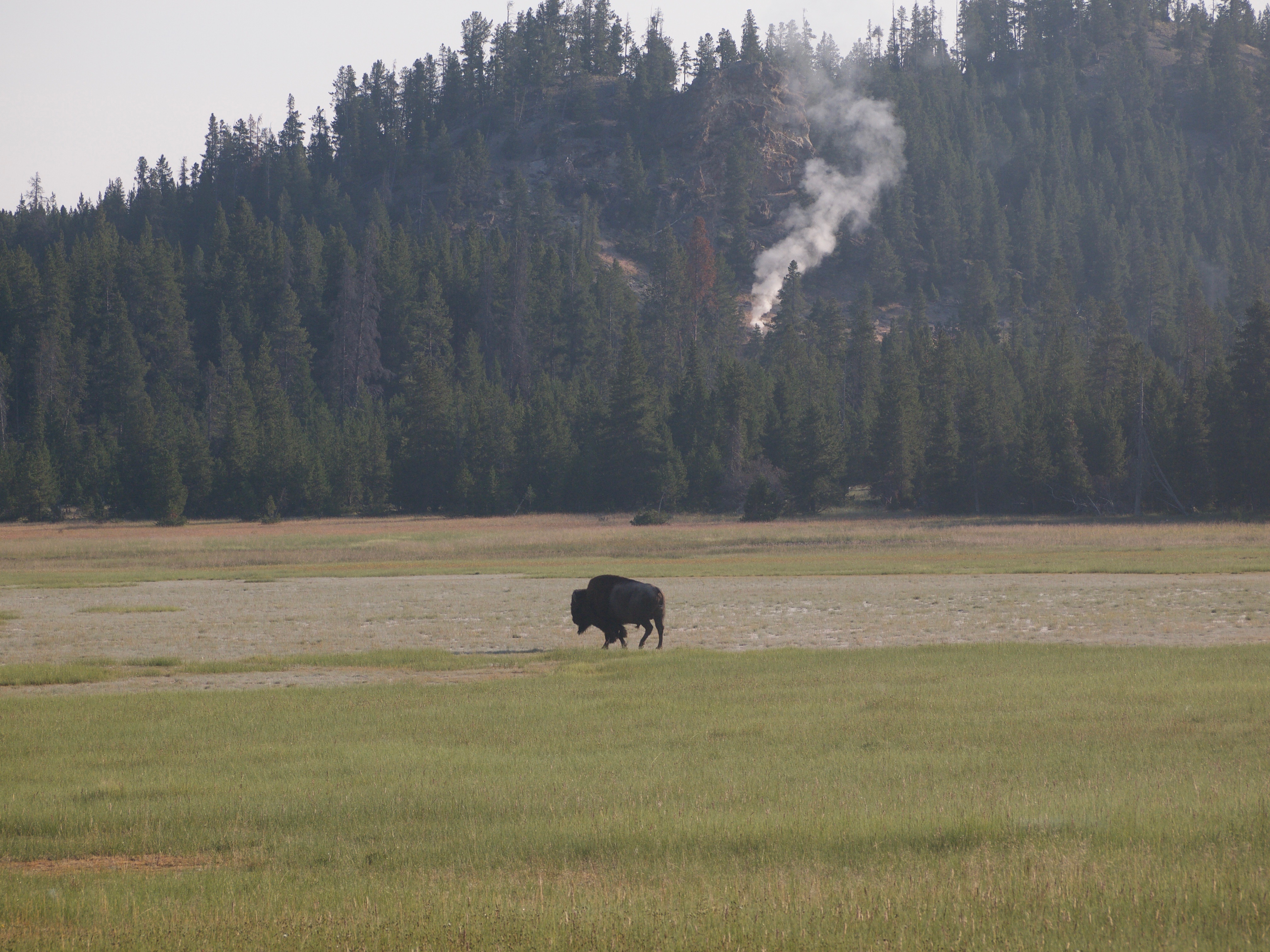
We got up even earlier than the previous day, and Mark thought it was a record early departure, about 7:15–especially given that we got packed up and checked out by that time. So that’s how our last Yellowstone day began, with another drive in from the West, but then South at the loop to backtrack through the Old Faithful “quadrant,” with stops in places where we had not stopped before. So we stopped at the Black Sands Basin, just before the Old Faithful area, and that was fabulous–another couple of great pools, and bubbling, steaming waterholes–the strangeness of a volcanic landscape just remains fascinating, no matter how often we see it. And Mark had a very good time shooting short videos that showed the bubbling and broiling of these geysers and springs. We had more of that when we went to the last of the geyser basins, at West Thumb, which is where our exploration of the last, i.e. southeast, quarter of the loop began. West Thumb is a bay of the enormous lake Yellowstone that was created by a volcano some 174,000 years ago, and the rim still has all these hot springs and mudpots and other volcanic features. We walked around on boardwalks including right along the lakeshore, and saw some springs that were so close to the edge that it really is surprising they stay intact rather than “merging” with the lake! We then drove up the lake for a bit and got out at a picnic area where we could get to the shore where it makes a little peninsula, Gull’s Point. The “sand” is almost black, but the lake was beautiful and still very peaceful–all in all, our morning was wonderful because the park was simply not so full yet, and we had a couple of walks to ourselves. The last bit up the loop before we got to the part we already knew was the Mud Volcano area and the Sulphur Springs. The Mud Volcano area was interesting because the volcanic activity has changed there so much over the last one hundred and even the last twenty years. Apparently, in the 1990s a whole bunch of smaller earthquakes changed many of the activities, so that even Mark remembered some of the geysers and springs as different. One of our favorites was the Dragon’s Mouth Cave, where the steam and roiling water inside a little cave causes these really spooky noises. The area was made extra fun by the fact that two bison really thought that the extra heat of the ground near the springs was very comfy, so we (and two zillion other tourists) got these great close-up shots of bison right by the springs.
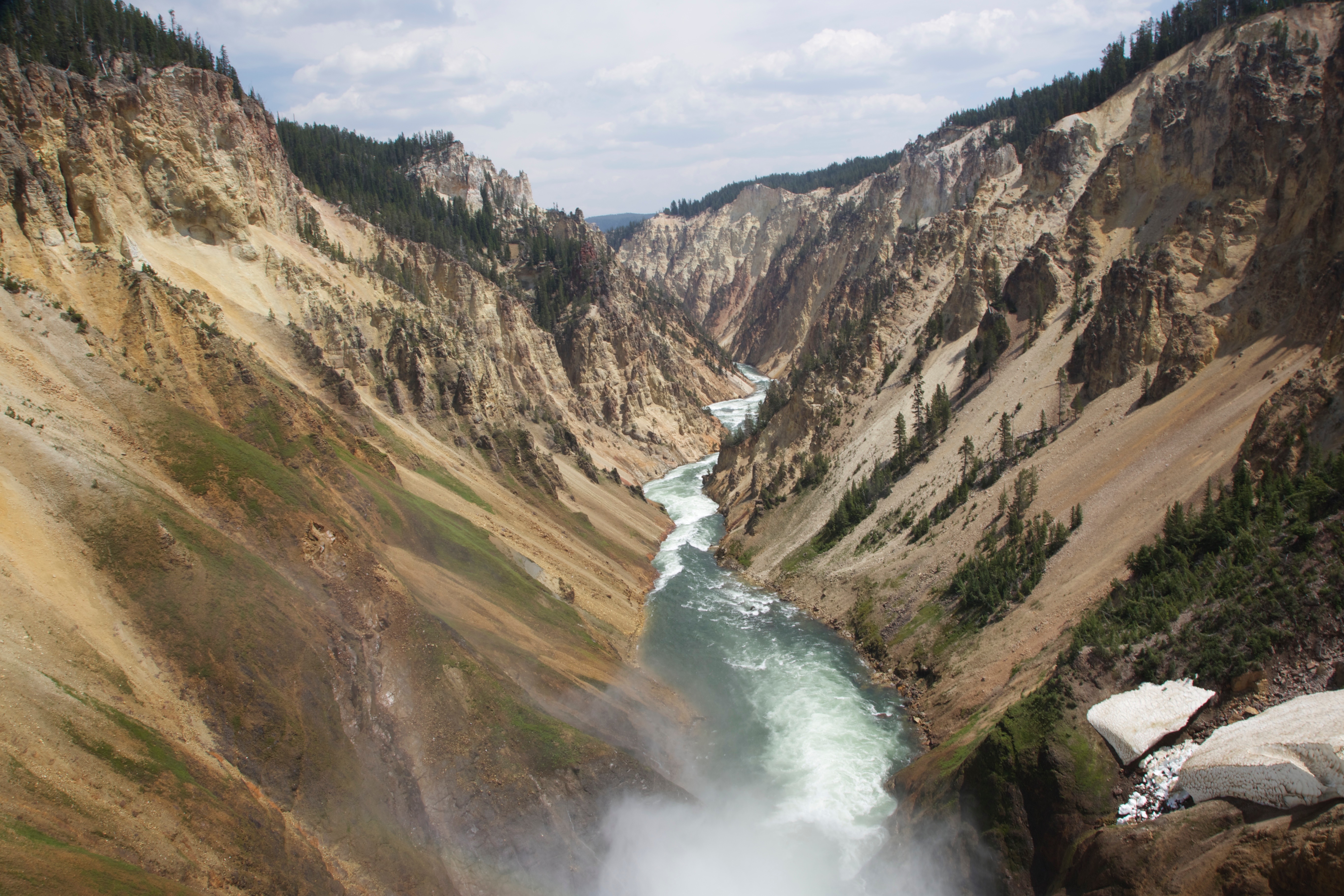
Once we were past this area and the “shortcut” west, we found ourselves a parking lot to have a picnic in, and by studying the educational displays realized that the entire lovely valley between the edge of the lake and the Yellowstone canyon, with its rolling hills and the river still moving along more slowly, is the bison’s home turf in all but the deep winter. We managed to spot a few more after we learned more about them, and it was also not surprising to encounter more “animal jams” and slowdowns in traffic on this stretch. We finally made it up to the falls, though, and, as planned, walked the North Rim of the Yellowstone Grand Canyon, including two heavy-duty up-and-down points, one right over the lower falls (we had done the upper the day before) and one called Red Rock Point, from which one could look at the lower falls from a distance. We also stopped at EVERY OTHER outlook point on the way, and had a great time with this little hike, which took about 2 hours, and according to Mark’s GPS, was about 5 miles all in all. This time, we had fabulous weather the whole time, and truly got some great views of the canyon with its many colors and shapes. The emerald-green river running through this red, yellow, orange, and beige rock just kicks the colors up a notch, and the views were spectacular.
By the end of our hike, it was about 3 pm, and we decided to head as directly as we could out of the park and on to find a place to stay in Montana, outside of the park. But the “directly” turned out to be harder than we thought. Although traffic finally settled down a bit inside the park once we were on the road off the loop to the northeast exit, we kept stopping for beautiful views and especially animal viewing. There was a large herd of buffalo, and later also an osprey in his nest, and it was hard not to keep pulling over to take in the view. Then we got out of the park and were in for even more of a surprise. Because it was only 4 pm, we decided not to look for a place to stay in either of the two little towns right outside the park (it would have been hard, anyway), and went on along the Beartooth Highway, which had come recommended by both the Yellowstone map and by our whitewater rafting guide in Jackson as very beautiful. But we were in for an absolutely stunning drive up into a mountain range we didn’t know existed, up these fabulous switchbacks, with canyons, bluffs and then snowcovered peaks. The pass itself goes over the a part of the Beartooth mountains that is very high for this area (10,900 feet), but the surrounding mountains are not any higher. That makes driving through feel like you’re on the very top of the world, with the world spreading out below with beautiful alpine lakes and meadows while above you is nothing else! It was really breathtaking–although I think that I got more out of the incredible alpine wildflower meadows, of whih I made Mark take several pictures, whereas he was more excited about the crazy guy who snowboarded down an incredibly steep slope on some of the many patches of snow that we kept seeing all over! I guess the truly wild animal is still always a human being with nutty ideas. He did okay, and his family was actually watching from where we were, too, but it did make me a bit nervous!
Our descent from Beartooth pass was also beautiful, but at the end, when we got to Red Lodge, MT, where we were hoping to find a place to stay or at least to eat, we had a somewhat unpleasant surprise. Yes, there were plenty of places to stay and to eat, but the town was packed from end to end with thousands of motorcycles and their riders, because this, as it turns out, is the weekend of the “Beartooth Rally” where three different routes through this areas are used for fun motorcycle riding. So we drove on, although we were pretty hungry and rather tired, because clearly every camp ground and hotel in the area was just packed to the rafters. We found a very nice “locals eat here” restaurant a couple of towns further on, which had just what we wanted, namely breakfast for dinner, and then we drove on all the way to Billings in hopes of a cheap freeway motel, which turned out to be impossible–both the state fair and some softball thing are going on, and almost everything was booked. So we got an expensive room instead (just for the one night), and frankly, I can’t wait to get out of Billings tomorrow. After all the beautfy of the mountains and then the very pretty bluffs on the way in, the industrial landscape and the classic Interstate wasteland makes me want to run far, far away from here! Which is the plan for tomorrow, anyway.